
Overview
In August of 2025, the South Washington Watershed District began a pilot project to harvest invasive hybrid cattails (Typha x glauca) from a large wetland complex adjacent to Armstrong Lake, a 22.7-acre shallow lake in Oakdale, MN. The goal of the project was to study whether cattail biomass harvesting would be an meaningful and cost-effective way to improve water quality. This project was lead by SWWD, with guidance provided by Barr Engineering Co., and field labor by the Washington Conservation District (WCD), and Conservation Corps Minnesota & Iowa (CCMI).
Background & Problems at Armstrong Lake
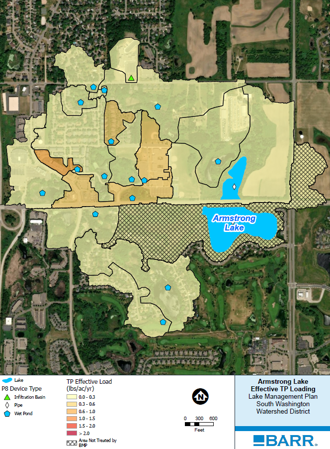
Armstrong Lake is a shallow waterbody located within the cities of Lake Elmo and Oakdale, Minnesota, in the northern tip of the SWWD. The lake is unique, as it was bisected into two basins by Washington County Road 10 (10th Street) sometime during the 20th century. The larger basin is on the southern side of County Road 10, and is the primary focus of SWWDs monitoring efforts. The smaller basin is on the northern side and approximately 6.2 acres in size. While the entire southern basin is 22.7 acres in size, only about 10 acres exhibit open water characteristics throughout the typical growing season. The lake is also only 5.5 feet deep. The Armstrong Lake subwatershed includes 572 acres of mixed use land, including single-family residential, commercial, forested and wetland open space, and some remnant cropland.
Given Armstrong Lake’s small size, even the low to moderate phosphorous contributions from its surrounding watershed are enough to create nuisance algae blooms, and generally poor water quality. During the summer, average phosphorus concentrations typically range between 60 to 100 ug/L, which exceeds water quality standards for the ecoregion (40 ug/L). Even in years with low chlorophyll a levels, water clarity is poor due to the constant water column mixing and sediment resuspension, creating high turbidity.
What is chlorophyll a?
Chlorophyll a is a measure of the amount of algae and cyanobacteria growing in a waterbody. Algae and cyanobacteria are a natural part of freshwater ecosystems however, too much of these organisms can cause aesthetic problems such as green scums and bad odors, and can result in decreased levels of dissolved oxygen. Some algae and cyanobacteria also produce toxins that can be of public health concern when they are found in high concentrations. (EPA)
What is turbidity?
Turbidity is the measure of the clarity or cloudiness of lake or river water, caused by suspended particles like sediment, algae, or organic matter. If water is highly turbid, it means there is a high concentration of particulate matter in the water column. This affects the ability of light to penetrate water, which impacts ecological productivity, recreational value, and habitat quality. (USGS)
Chloride concentrations have also been steadily rising over the last 20 years, from 54 up to 202 mg/L. The Minnesota Pollution Control Agency (MPCA) sets a chronic standard of 230 mg/L. Armstrong Lake is not currently listed as Impaired on the Minnesota Section 303(d) impaired waters list.
A variety of water stormwater ponds from commercial and residential development in the area provide some treatment of stormwater runoff in the Armstrong Lake subwatershed. However, the limited opportunities for redevelopment in this area prevent the advancement of best management practices (BMPs) to remove phosphorus runoff and prevent it from entering Armstrong Lake. There are a few small-scale residential BMPs that have been implemented in the past; but the primary targets for BMPs are road corridors and commercial property. There simply is not much, if any, available land remaining in these areas for larger BMPs.
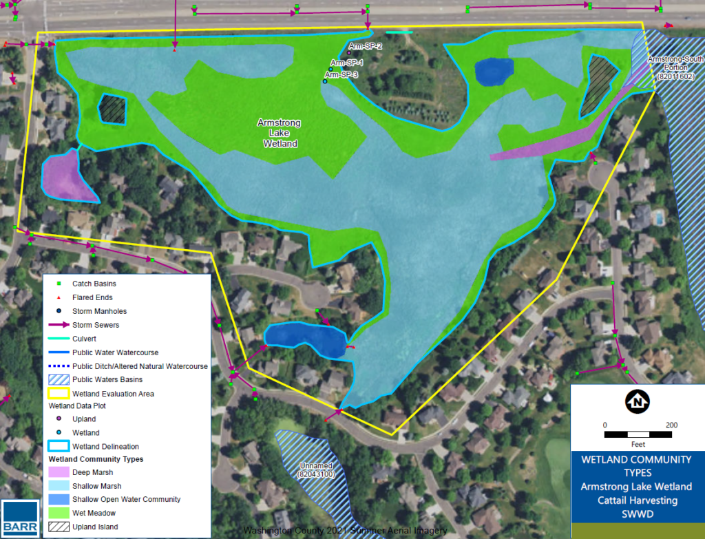
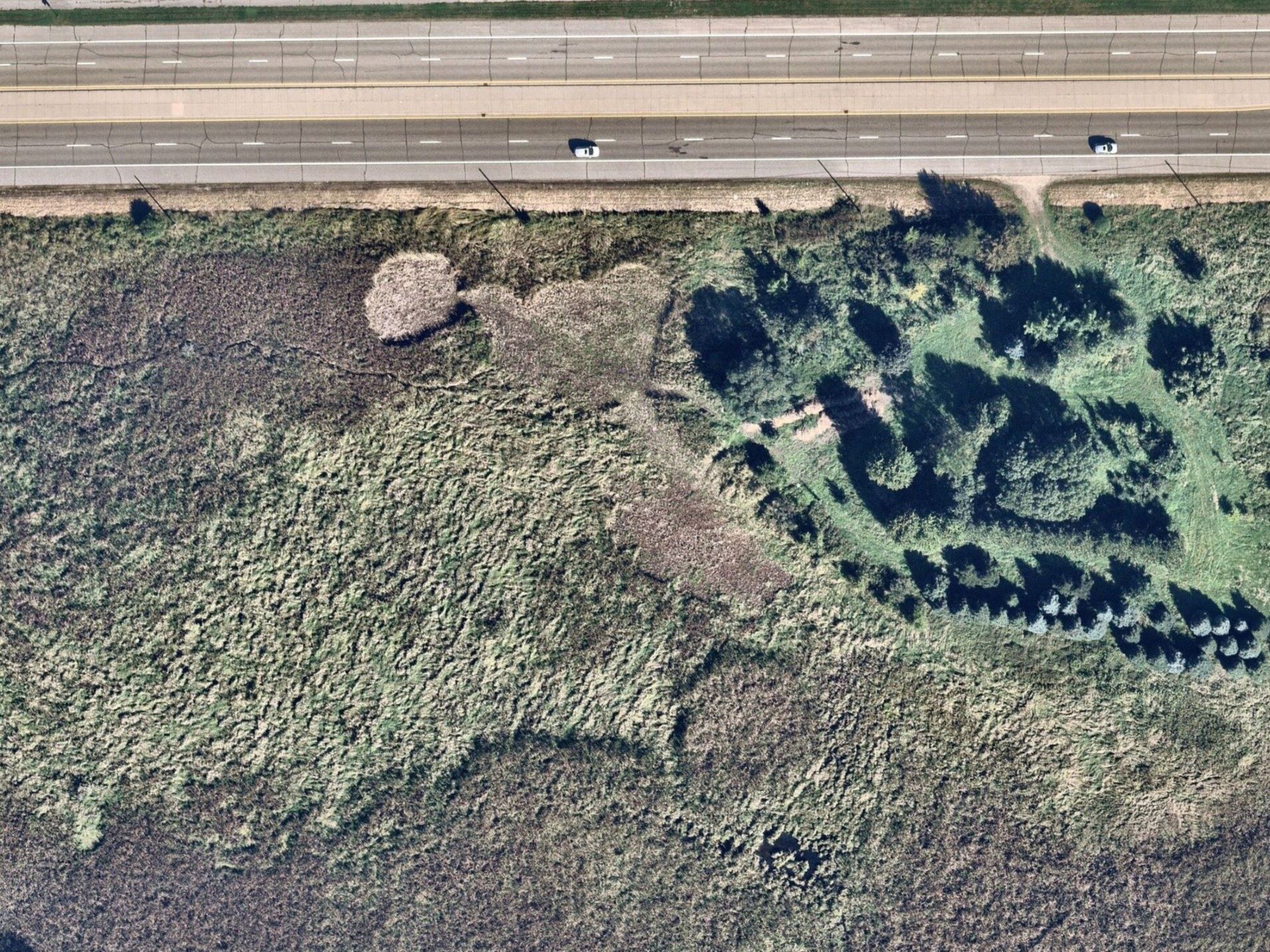
Armstrong Lake is bordered to the west by a large wetland feature of approximately 21 acres in size. Of this, 11.2 acres (53.3%) are covered by invasive hybrid cattail (Typha x glauca), Roughly 300 acres of the lakes 572-acre watershed drain through this western wetland complex. The idea of harvesting cattails to reduce nutrient loading into the lake was identified and reviewed as a potential BMP in both the Armstrong Lake Subwatershed Retrofit Analysis (SWWD, 2018) and the Northern SWWD Stormwater BMPs Feasibility Study (Barr, 2019).
In the 2018 study, cattail harvesting was identified as the top ranked of five BMPs for phosphorus removal, with a potential annual reduction range of 40 pounds (winter harvest) to 350 pounds (growing season harvest). These estimates were confirmed in the 2019 study.
A 2011 University of Manitoba study showed that harvesting cattails and clearing deadfall can result in greater numbers of emerging plants and an overall increase in cattail biomass production in the years following harvest (Grosshans, 2011). The study also concluded that an early fall harvest would yield the greatest benefits for nutrients removal via biomass harvesting. In Cattail Management in the Northern Great Plains by Svedarsky, et al., valuable literature review of the cattail harvesting concept guide that greatly influenced the design of this project (University of Minnesota, 2016). SWWD set out to test the feasibility of some of these theories locally in the fall and winter of 2025-2026.
Methods
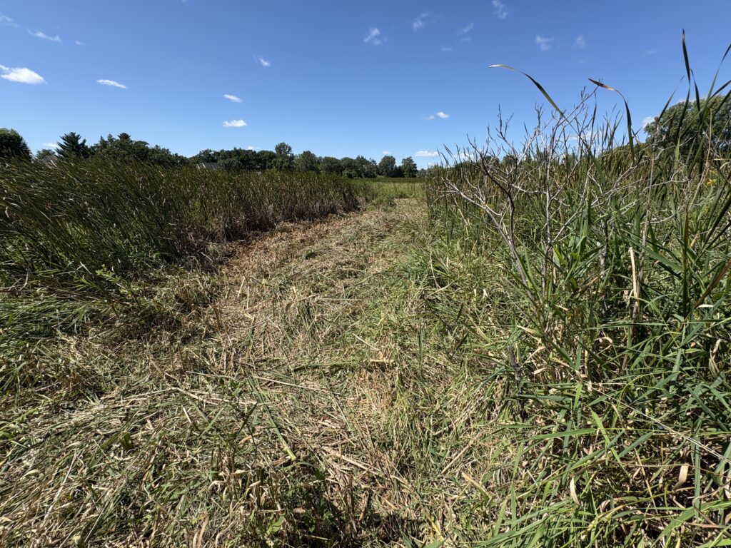
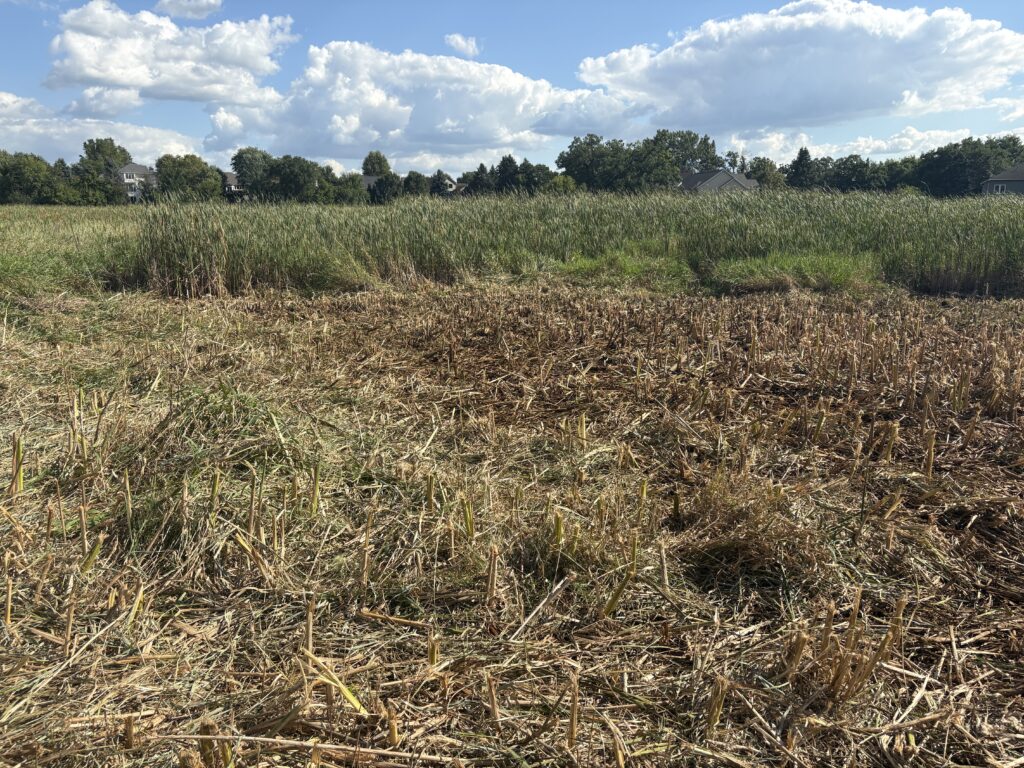
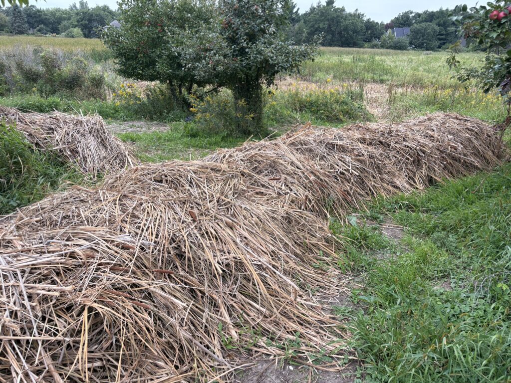
SWWD contracted with the Washington Conservation District (WCD) to provide field work for a small manual harvest of the cattail biomass from August 25th to 28th, 2025. WCD was assisted by a crew from the Conservation Corps Minnesota & Iowa (CCMI) for four days of work. The high water levels within the wetland limited the areas the crew could safely work in, which kept them to the northern edge of the wetland just west of a large upland area owned by the City of Oakdale. Crew members utilized hand-operated brush cutters and weed whips to mow cattail stalks above the water line. Cut materials were then hauled to the nearby staging area on small sleds. Approximately 0.4 acres of cattail dominated wetland were mowed and harvested by the crew, which was then confirmed by GPS survey.
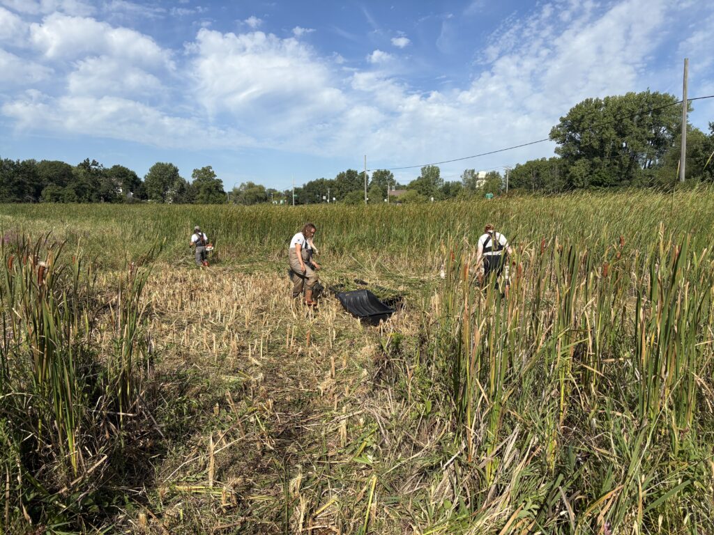
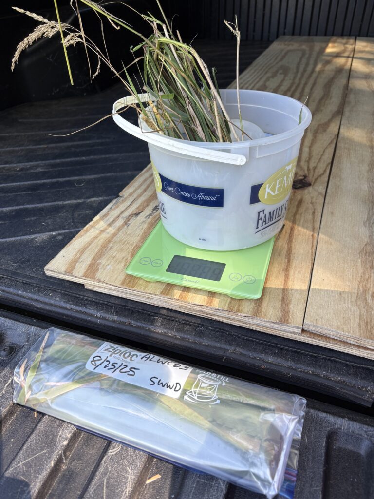
SWWD staff collected samples representative of both flowering and non-flowering harvest cattail plants including leaves, stems, and flowering parts (if present) for lab analysis. Two flowering and two non-flowering samples were taken each day, for a total of eight cattail samples. Two samples of reed canary grass were also collected in the same manner for general comparison. Each individual sample was then cut into smaller pieces for storage in one gallon plastic bags. The total mass for each sample was collected using a digital scale, and samples were held on ice in a cooler before being transferred to a refrigerator at the SWWD office. All samples were delivered to the University of Minnesota’s Research Analytical Laboratory (RAL) on August 27th, 2025.
A the lab, samples were dried and ground for analysis.
- Elemental Analysis by Inductively Coupled Plasma – Optical Emission Spectrometry
- Dry ashing method (485°C ashing temperature)
- Al (Aluminum), B (Boron) Ca (Calcium), Cd (Cadmium), Cr (Chromium), Cu (Copper), Fe (Iron), K (Potassium), Mg (Magnesium), Mn (Manganese), Na (Sodium), Ni (Nickel), P (Phosphorus), Pb (Lead), Zn (Zinc)
- Nutrient Extraction with Colorimetric Analysis – CaSO4 Extraction
- NO3–N (Nitrate-Nitrogen), Cl– (Chlorine)
- One set of duplicate samples were analyzed for quality control (no issues noted)
- SWWD was primarily interested in results for P, NO3–N, and Cl
SWWD staff returned to the harvest site one week later to complete a series of cattail stem counts to aid in estimating the number of plants, and biomass, of cattails within the wetland. Ten sample locations were established by randomly throwing a ball to different points within the harvest wetland area. The final resting location of the ball was set as the center of a 24″ x 24″ stem count plot. Cut cattail stems were counted in each plot, and the data was used to extrapolate later calculations.
To provide a comparison between a later summer harvest, a winter cattail harvest, and an estimate of nutrients lost due to seasonal senescence, an additional six representative cattail samples were collected from the adjacent perimeter of the originally harvest portion of the Armstrong Lake Wetland on February 11th, 2026, and submitted to the RAL for the same analytical processing.
Data Results & Findings
Data returns from this project provided a variety of interesting and relevant findings.
Wetland Area & Cattail Biomass Estimates
- Armstrong Lake Wetland Total Area: 21 acres (914,760 ft2)
- Armstrong Lake Wetland Cattail-dominated Area: 11.2 acres (487,872 ft2)
- Cattail Stem Counts: Range of 10-34 stems per 4 ft2, average of 17.6 stems per 4 ft2
- Estimated Total Number of Cattail Plants in 11.2-acre Harvestable Area: 2,146,637
- Cattail Biomass per Plant Stem: Range of 12-198 g, average of 79 g (growing season, wet)
- Cattail Biomass per Plant Stem: Range of 11-57 g, average of 31 g (winter, dry)
- Estimated Growing Season Biomass of Harvestable Cattail in Wetland: 169,584 kg (187 tons)
- Estimated Winter Biomass of Harvestable Cattail in Wetland: 66,546 kg (73 tons)
The harvested cattail biomass was left onsite to dry in an upland location for about two weeks before being loaded into a commercial roll-off container by the City of Oakdale. At the time it was hauled to a commercial composting facility, the 0.4-acre harvest area yielded an approximate total of 30 cubic yards of plant material. There was a noticeable presence of reed canary grass within the harvest material. However, its relatively low biomass and the low percentage of reed canary grass versus cattail in the harvested material led us to disregard it for the purpose of this analysis.
Nitrate-Nitrogen (NO3–N) Results
Data returns for NO3–N showed samples ranging from 1.41-11.62 mg NO3–N per kg of biomass, for an average of 0.0008%. The scale of NO3–N removal associated with a large-scale cattail harvest in this location is insignificant. A successful summer harvest could be expected to remove 1.36 kg of NO3–N (3 lbs). Winter results were even lower, with plants containing roughly half of the NO3–N found during the growing season.
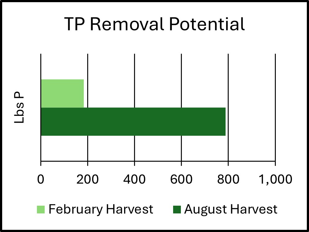
Total Phosphorus (TP) Results
The cattails harvested during the growing season contained a range of 1,322-3,398 mg TP per kg of biomass, for an average of 0.2108%. While this is a seemingly small number, when extrapolated out to a full-scale growing season harvest, the estimated total mass of phosphorus potentially removed from this wetland grows to 357.5 kg (788 lbs) on average. The total estimated range is between 456-1,214 lbs TP per harvest. This result, based on field data, exceeds all previous TP reduction estimates SWWD had generated for the activity.
The cattails harvested during the winter contained a range of 865-2,403 mg TP per kg of biomass, for an average of 0.1260%. Due to the lower total biomass available for harvest, and the lower retained phosphorus, the potential winter phosphorus removal is estimated at 83.8 kg (184 lbs).
Recently completed in-lake modeling for the South Basin of Armstrong Lake shows typical expected TP loads from the surrounding watershed as ranging between 17 and 65 pounds annually depending on precipitation patterns. As expected, wetter years will result in higher watershed TP loads. We can reasonably presume that removing hundreds of pounds of TP from the upstream wetland through biomass harvesting will not result in an equivalent direct reduction for Armstrong Lake itself. However, if repeated removals can again turn the wetland into a TP sink by encouraging the growth of “replacement” cattail biomass, it is fair to conclude that watershed loading through this wetland to Armstrong Lake can be significantly reduced on an annual basis compared to the current condition. About 50% of Armstrong Lake’s watershed lies upstream of the wetland complex, including nearly all the densely developed commercial areas.
Chloride (Cl–) Results
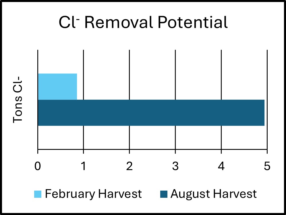
The harvested cattail biomass also confirmed a suspected propensity to retain a high concentration of Cl–, ranging from 18,867-34,223 mg Cl– per kg biomass, for an average of 2.6368%. Extrapolated out to a full-scale growing season harvest, the estimated total mass of Cl– potentially removed from this wetland is 4,485 kg (4.94 tons) on average. The total estimated range is between 3.79-6.00 tons Cl– per harvest.
The cattails harvested during the winter contained a range of 4,894-24,632 mg Cl– per kg of biomass, for an average of 1.1745%. There was a much more distinct difference noted between non-flowering (average 6,130 mg/kg) and flowering cattails (average 22,975 mg/kg) in the winter. Samples collected during the growing season did not exhibit a noticeable difference. In fact, non-flowering cattails exhibited slightly higher Cl– content during the growing season. Due to the lower total biomass available for harvest, and the lower retained chloride, the potential winter chloride removal is estimated at 781.6 kg (0.86 tons).
Pilot Project Costs & Outcomes
SWWD set out to complete this pilot project with minimal investment as a proof of concept. Direct costs incurred to complete 0.4 acres of manual harvesting work and data analysis included the following:
| Field labor for harvesting work (WCD) | $3,136.50 |
| Field labor for harvesting work (CCMI) | $5,400.00 |
| Disposal (commercial composting) of harvested cattail materials | $750.00 |
| Laboratory Analysis – Growing Season (RAL) | $962.50 |
| Laboratory Analysis – Winter (RAL) | $627.50 |
| TOTAL $10,876.50 |
Based on lab analysis and extrapolation, the pilot project’s harvest of 0.4 acres removed up to 28 pounds of TP from the Armstrong Lake Wetland at a rate of $388 per pound. An additional 352 pounds of Cl– were removed from the system by this effort.
Overall, winter cattail harvests appear to have the capacity to remove roughly 20-25% of the mass of phosphorus and chloride as a late growing season harvest. However, there is significant uncertainty surrounding the conditions of the wetland in late August and if those conditions would prevent a large-scale harvesting operation. How much physical impact or sediment disturbance would be expected within the wetland? What type of equipment would be required? Are there contractors available to complete the work? Would targeted manual harvesting, possibly on a larger scale, be a more prudent programmatic approach?
Conclusions & Continued Study
The pilot project has been successful in establishing a local proof-of-concept; there are measurable pollutant reduction benefits to be realized within the Armstrong Lake watershed by this type of project. Several things remain unclear, however, including the costs and impacts of scaling this effort up to a full-basin removal, what portion of the pollutant removal benefits can be realized in Armstrong Lake itself (in both the short-term and long-term), and what ecological community changes may result over time after repeated cattail harvests.
Full-Basin Harvesting Feasibility
Completing a full-basin harvest with a crew providing manual labor, like the approach SWWD took in 2025 is not a feasible option. Cattail fringes around the perimeter of the basin could be harvested in this fashion, provided that multiple access points could be secured, but crew safety will always be a concern, and seasonal high water could derail the operation entirely. Hiring a contractor with amphibious equipment to complete the growing season harvest would be essential – and likely significantly more costly. Additional research in this area is required before pursuing a full basin growing season cattail harvest in this location.
Regardless of regulatory jurisdiction, attention must also be paid to Minnesota Department of Natural Resources recommendations regarding the timing of a full-basin harvest. Despite their non-native, invasive status, narrowleaf and hybrid cattail still provide important habitat for a wide variety of fauna. Disturbing these areas at critical times (waterfowl nesting, for example) could be detrimental to desired and/or protected native species.
Additionally, even with amphibious or very low-weight-ratio tracked harvesting equipment, there are bound to be significant short-term disturbances to the surface sediment profiles within the wetland. If weather patterns do not provide enough post-harvest time for the wetland to heal before large rain events, disturbed nutrient-rich sediments could be mobilized from the wetland and downstream into Armstrong Lake, negating potential benefits from the harvest itself.
Previous studies have also focused on the concept of harvesting cattail biomass for use as agricultural fertilizer. Shredding and spreading the biomass over area croplands could help to “naturally” enrich crop soils. Additional study would be needed to review any concerns about transport of other stormwater pollutants (chloride, heavy metals, PFAS, PAHs, etc.) to croplands via the cattail biomass.
Growing Season vs. Winter Harvest
From a gross pollutant removal perspective, completing a harvest during the late growing season provides the most benefit by far. Data gathered indicates that a winter harvest may only provide 20-25% of the phosphorus and chloride removal potential. However, completing a winter harvest in strong frozen conditions in January or February would minimize both the ecological and sediment disturbance potential of the operation while also possibly resulting in a reduced project cost. A warm winter season could derail this option as strong ice cover and frozen ground would be required to support the weight of traditional harvesting equipment; even this assumption would be subject to additional investigation.
Based on the data gathered, SWWD sees the greatest potential value in targeted manual cattail harvesting during the growing season. If a CCMI crew were hired and managed internally by SWWD staff, one week of harvesting work could conservatively remove 20 pounds of phosphorus at a cost (crew labor plus disposal) of roughly $6,200 ($310/pound TP removed). Incorporating this as a type of targeted operational BMP, like street sweeping or operating an alum facility, could have long-term sustainable and reproduceable benefits for surface water resources within the watershed.
Ecological Benefits of Cattail Harvesting
Many wetland areas within the SWWD exhibit varying degrees of monotypic stands of narrowleaf and hybrid cattail, be they covering the entire basin or lining the fringe of open water areas. Strengthening the ecological diversity of these habitats by disturbing and/or diminishing the cattail density aligns strongly with SWWD’s resource improvement goals beyond simply reducing nutrient loading to surface waters. It will be important to watch how the vegetative community within the Armstrong Lake Wetland pilot project area reacts over the coming seasons. The harvesting activity completed here was not undertaken with the stated purpose of eliminating or even reducing the cattail stand. However, if this additional benefit can be achieved slowly and sustainably over time, it would provide further evidence in support of SWWD pursuing cattail harvesting as a programmatic BMP in this location – and possibly others.
References
Barr Engineering Co. Northern SWWD stormwater best management practices feasibility study. South Washington Watershed District. March 2019.
Barr Engineering Co. Cattail harvesting program feasibility – Phase 1. South Washington Watershed District. August 2022.
Barr Engineering Co. Wetland Delineation Report: Armstrong Lake Wetland Cattail Harvesting. South Washington Watershed District. June 2023.
Barr Engineering Co. South Washington Watershed District Lake Management Plan. South Washington Watershed District. December 2025
South Washington Watershed District. Armstrong Lake Subwatershed Retrofit Analysis. September 2018.
Full Report
Questions? Contact Kyle Axtell, Watershed Project Manager at [email protected]